There was a need to move away from Google Maps for locality data in India due to increase in Google Maps geocoding pricing. We could find very good Village data from Local Government Directory. But the urban data still consisted of government bodies in urban areas, but not the new and popular names they are referred with. For example, we may not find HSR Layout (Bangalore)
Data Sources considered
This needs to be expanded. WIP ##### India postcode data https://www.data.gov.in/resource/all-india-pincode-directory-till-last-month This contains only the postal codes. If an urban area does not have a post office, we cannot find it in this dataset
import pandas as pdfrom pathlib import Pathpostcodes = pd.read_csv(Path.home()/'Downloads/pincode.csv', low_memory=False)print(f'postcodes shape - {postcodes.shape}')print(f'number of unique postcodes - {postcodes["Pincode"].nunique()}')postcodes.head(3)
postcodes shape - (157126, 11)
number of unique postcodes - 19300
CircleName
RegionName
DivisionName
OfficeName
Pincode
OfficeType
Delivery
District
StateName
Latitude
Longitude
0
Andhra Pradesh Circle
Kurnool Region
Hindupur Division
Peddakotla B.O
515631
BO
Delivery
ANANTAPUR
ANDHRA PRADESH
14.5689
77.85624
1
Andhra Pradesh Circle
Kurnool Region
Hindupur Division
Pinnadhari B.O
515631
BO
Delivery
ANANTAPUR
ANDHRA PRADESH
14.5281
77.857014
2
Andhra Pradesh Circle
Kurnool Region
Hindupur Division
Yerraguntapalle B.O
515631
BO
Delivery
ANANTAPUR
ANDHRA PRADESH
14.561111
77.85715
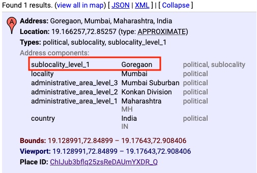
Google Maps vs Ola Maps
When we search for ‘Goregoan, Mumbai’ in https://developers.google.com/maps/documentation/geocoding/overview#geocoding-requests, it is identified as a sublocality.
num results - 5
1 - Lupin, Mantri Park, Goregoan East, Lupin, IGIDR, Nagri Niwara CoOperative Housing Society, Goregaon, Mumbai, Maharashtra, 400065, India
2 - Goregoan West, Teen Dongari, Prem Nagar, Goregaon West, Mumbai, Maharashtra, 400104, India
3 - Goregoan East, Peru Baug, Churi Wadi, Goregaon, Mumbai, Maharashtra, 400063, India
4 - Parking Goregoan, Laxmi Rd, Ganesh Nagar, Goregaon, Mumbai, Maharashtra, 400065, India
5 - Goregoan Properties, 138, 4, Jawahar Nagar Rd, No 9, Goregaon West, Mumbai, Maharashtra, 400104, India
We can see that Ola Maps returns specific addresses with matching names, but not the sublocality. We can retrieve sublocality from the returned components, but if there are no matching addresses, we will miss out sub sub-localities
Neonatim hosted search
Let us now check the hosted Neonatim search - https://nominatim.openstreetmap.org/
When we search using this, we can find ‘Visalakshinagar’, but I dont find it in my local installation. So looks like some entries are not built correctly.
So even if we find an entry, which admin_level should be considered for an ‘urban locality’?